A Brief Geologic Journey Back in Time in Lake Oswego
By Jim Fisher
The rocks, sediments, and soils of Lake Oswego have a long and complex history. These earth materials, together with our ponds, streams, and Oswego Lake, have combined through time under the natural processes of weathering and erosion, to create the varied landscapes we so much value. Like everywhere on earth, today’s varied landscapes can be traced back to the rocks and earth forces of the past.
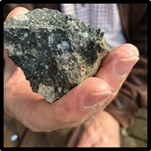
If we were to magically be able to go back in time to about 42 million years ago, we would see that there was no Lake Oswego, only the Pacific Ocean. But a landmass was (slowly) approaching the shoreline of western Oregon at this time; geologists call it “Siletzia”. This ancient mass of rock, probably a volcanic island complex, was rafted eastward across the Pacific even as the North American continent was being translated westward by the deep tectonic forces of plate tectonics: the slow circulation of crustal rocks by forces deep in the mantle of the earth. Instead of plunging into the mantle, the more buoyant Siletzia rocks became attached to North America, moving the Pacific shoreline westward. The Siletzia suite of rocks now underlie much of NW Oregon. Today in Lake Oswego these rocks are represented by a geologic formation called the Basalt of Waverly Heights-named for the very good surface exposures along the east bank of the Willamette River (eg. Elk Rock Island).

Waverly Heights Basalt from Elk Rock Island
Photo by Jim & Barbara Fisher

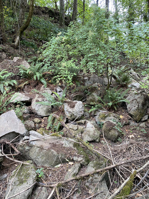
Basalt Rock Escarpment at Village on the Lake
Photo by Michael Buck
Today in Lake Oswego, rocks from the Columbia river Basalt group, circa 17.5 million years ago and Basalt of Waverly Heights, circa 42 million years ago, are found in contact with one another in a few sites. During the interval between the two events, the cascades erupted; the Oregon coastline spread westward; the Coast Range and Willamette Valley formed; and the ancestral Columbia River was established. In addition, thanks in part to the rise of the Cascades, Oregon’s climate cooled and the vegetation transitioned from a tropical forest to a savanna-like plain that is expressed in Central and Eastern Oregon*.
During the Middle Miocene epoch, beginning about 17.5 million years ago and continuing sporadically until about 6 million years ago, massive eruptions of basaltic lava flowed westward into what is now Lake Oswego, overlapping the older Basalt of Waverly Heights. Several of these enormous lava flows continued all the way to the Pacific Ocean (eg. Seal Rock). There is considerable evidence that these lavas, known as the Columbia River Basalt Group, are related to the mantle “hot spot” that is currently located under Yellowstone National Park in NW Wyoming: quite an intriguing story and something to ponder when looking at Iron Mountain, the south shore of Oswego Lake, the cliffs along Hwy 43 or the rocky banks of the Willamette River.
From about 6 million years until around 2.5 million years ago, there is another time gap in the geologic record in Lake Oswego. During this time, the Columbia River lava flows that lay exposed on the surface experienced rainfall, stream flow with accompanying erosion, and chemical weathering from groundwater-all processes common to geologic materials everywhere exposed at the earth’s surface. This time gap provided the opportunity for weathering processes to leach silicate minerals from the Columbia River basalts in Iron Mountain, thereby concentrating the iron minerals left behind and creating the bog iron ore later mined by the Oregon Iron Company, beginning in 1865. Plate tectonic forces continued as well: squeezing, folding, stretching and rotating crustal rocks and resulting in large blocks of rock moving relative to one another. In fact, as Goodrich points out, it is hypothesized that these earth movements are ultimately responsible for the formation of Oswego Lake itself2. This stretching also resulted in the creation of the Portland Basin and the opening of deep conduits that allowed rising magma from the depths of the subduction zone to begin erupting in a series of small volcanoes in the Portland Basin beginning about 2.5 million years ago. Today, about 80 of these small volcanoes are recognized including, in Lake Oswego, Mt. Sylvania, Cooks Butte, and the Waluga Reservoir hill (and bike skills park) in East Waluga Park. These lavas are known as the Boring Lavas, named after the small town in Clackamas County. The oldest of all the 80 volcanic vents may be Cooks Butte, while the youngest appears to be the Beacon Rock on the Washington side of the Columbia River, dated at about 57,000 years old.
All earth materials in Lake Oswego younger than the Boring Lavas are unconsolidated sediments including the recent (Holocene) deposits of current drainage systems (ie. stream alluvium, bog sediments, lake and river deposits) and the 13-17,000 year old (Pleistocene) Missoula Flood Deposits: sediments from a series of 90 catastrophic floods originating in glacial Lake Missoula where a glacier lobe sporadically blocked the Clark Fork River. Periodically, the ice dam that formed the lake would fail, releasing a gigantic cataclysm of water-the largest known flow of fresh water on earth, calculated to be in excess of 16 million cubic feet per second*. The deepest of these floods in Lake Oswego reached a surface elevation of about 400 feet, enough to bury downtown beneath 300 feet of water! These floods carved channels and left deposits all over Lake Oswego and down the Willamette Valley as far as Cottage Grove. Chunks of glacier ice were rafted by the flood and a few of these ice chunks dropped boulders where they became hung up on obstructions and melted. Mike Goodrich reports that a large glacial erratic (6 feet +/-) was present at an elevation of 350 feet on Canyon Drive on the south side of Oswego Lake (since removed to form a parking space!). Homeowners, contractors –and geologists- are well aware of the large, hard boulders left by the floods in Old Town, Lakewood, Bryant, Rosewood and Blue Heron neighborhoods. Many other neighborhoods are underlain by finer grained flood deposits-sands and silts from lower velocity or slackwater portions of the floods.
The oldest unconsolidated deposits in Lake Oswego are represented by a mixed deposit of sand, silt, clay and gravel now exposed only in the Hallinan neighborhood. These deposits appear to correlate with other deposits east of the Willamette River, estimated to be over 1 million years old and associated with an ancestral stream system headed in the Cascades.
The bedrock and unconsolidated sediments of Lake Oswego provide the basic starting ingredients for the final, living elements of our landscape: soils and vegetation. Think of a bare rock or soil surface not modified by human activity: The surface is exposed to sun, wind and rain such that physical and chemical weathering begin immediately. Besides the physical and chemical effects of water, other physical forces are operating continuously on the earth’s surface: wind, gravity, solar radiation and earthquakes. Water is present On the ground on a rainy day of course, but it is present In the ground all year long-at varying depths depending on the season. Water can penetrate the ground because the earth is not completely solid but also includes macro- and micro-voids that allow water and air to enter soil and rock. Air voids can occupy a third or more of the volume of soil, for instance. And yes, healthy soils really are alive! Nature adds the living component of soil: viruses, bacteria, archaea, fungi, protozoa and the larger critters such as earthworms, beetles and centipedes: macro- and microscopic organisms by the billions that facilitate the weathering and decomposition of mineral soils through the addition of a food source. That food source is living and dead organic matter: that is, carbon. In addition to the above processes, the other primary factors in soil formation are the landscape position of a site and, most importantly: TIME. A fully mature soil in a temperate forest, for example, can take hundreds to thousands of years to develop. All these elements combine to produce the varied soils in our community. In fact, the USDA Resource Conservation Service maps 28 different “soil series” in Lake Oswego, not counting numerous sub-types. More detail on our local soils can be found online at Websoilsurvey.nrcs.usda.gov/app/WebSoilSurvey.aspx.
The above mini-history is just the barest summary of past geologic events. Further information on the geology of Lake Oswego, including geologic hazards, is available online at DOGAMI (Oregon Department of Geology and Mineral Industries) and the USGS (United States Geological Survey). Also, the City website includes maps showing foundation and slope stability hazards. Numerous books and other hard cover publications are available at Portland State University, Oregon State University, and the University of Oregon. Theses covering geologic topics of local interest abound in these and other universities throughout the United States.
* Bishop, Ellen Morris, 2003, In Search of Ancient Oregon, a Geological and Natural History, Timber Press.
